THE LANDSCAPE SETTING
The setting
Deerhurst is sited next to the River Severn, which in the prehistoric period had ritual and symbolic value as well as being a navigable waterway. There are Bronze Age barrows in the area, dating from a period after around 2,500 BC when there is pollen evidence for the increased clearance of woodland and expansion of grassland. There is now clear evidence from around 1500 BC for the establishment of farming landscapes with their settlements. The Severn was also an important cultural boundary, and by the late Iron Age settlement had taken different forms to either side of it – a situation which has persisted ever since.
The first known embankments for flood protection and taking in new farmland along the Severn to the south of Deerhurst – some of the earliest recorded in Europe – date from the Romano-British period (43-410 AD). Gloucester, a short distance to the south, was developed firstly as a forward legionary base near to the Fosse Way, and from AD 97 as a high-status colonia for retired legionaries as developed across the Empire. There is a concentration of material suggesting the presence of Roman buildings around the church and to the south of Odda’s Chapel. These probably included a villa involved in trade along the river, one of several extending towards Tewkesbury. The present main road (A38) from Gloucester to Tewkesbury (the site of another Roman settlement), sited on higher ground on the east side of the parish, follows the line of a Roman road for much of its course.
The siting of the church
The building of the church, its community and Odda’s Chapel and noble residence between the 9th century and the Norman Conquest relates to the establishment of the pattern of settlement in farmsteads and villages which has been adapted and reinforced to the present day. The boundaries of the Saxon and medieval church and monastic community – within which are the graveyard and the remains of fishponds used by the priory – are defined by earthwork banks and ditches. Highly significant is Deerhurst church’s siting at the highest point of a sand-and-gravel land-island surrounded by alluvium which would have been subject to flooding. This is a very characteristic location for important early minster churches, with communities which had a pastoral role but were also mindful of the need for escape from the world like the early desert fathers who inspired the development of monasticism in the 6th and 7th century British Isles.
The name Deerhurst means ‘wooded hill or hillock frequented by deer’, and probably refers to the low sand-and-gravel island on which the village of Deerhurst now stands. It probably also developed as an estate centre close to the settlement where British/Welsh speakers lived as slaves or serfs working the land (Deerhurst Walton). Odda’s Chapel, and the site of his residence, are sited within an area of land to the south of the ancient village street which was bounded by banks and ditches. Another indication of Deerhurst’s importance in the Anglo-Saxon period is that the island to its south – The Naight – was chosen as the site of an important meeting between the Danish King Cnut and the newly-crowned Edmund Ironside in 1016, after Edmund’s defeat at the battle of Assandun and probably also at a further battle in the Forest of Dean. Edmund took Wessex, and Cnut the rest of England, bringing to an end decades of warfare.
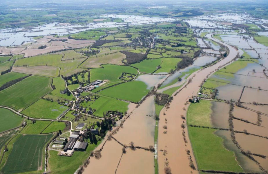
Deerhurst in partial flood, looking south and clearly showing The Naight as an island to the south-west (Image © Historic England Archive 33611/043)
The Tewkesbury district
By the 11th century Tewkesbury had emerged as a significant trading centre at the confluence of the rivers Severn and Avon, and communities along the river were supplementing their income through trade and fishing. At Deerhurst there are also earthworks remaining from the medieval settlement, defining the platforms of at least ten houses or farmsteads and probably relating to the great period of settlement expansion brought to an end by the events of the early-mid 14th century – floods, crop failures and famine followed by the Black Death of 1348-9 and successive epidemics afterwards. Some or all of these dwellings and outbuildings had been vacated by the early 16th century, partly as a result of continual flooding, when Deerhurst was described as a poor village. The frequency of floods was the reason for many houses being pulled down in the late 1950s on the orders of the then Cheltenham Rural District Council, using slum clearance legislation to evict homeowners and occupiers from their homes (many of them of 17th century or earlier date).
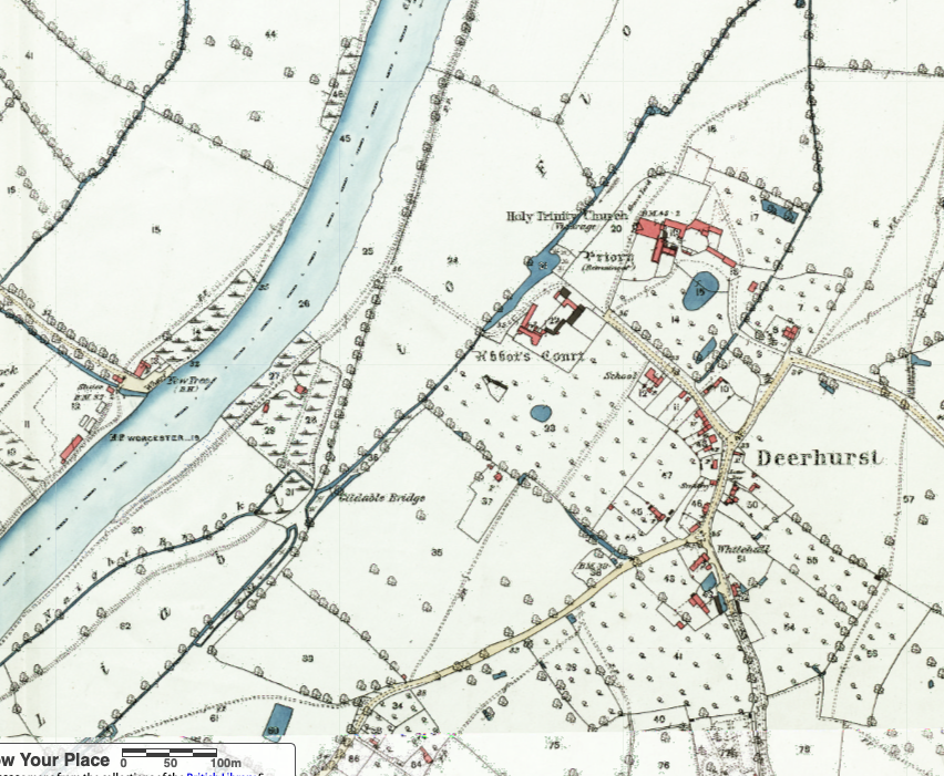
Ordnance Survey map of 1884, showing the relationship of the church and Priory Farm to the village and Abbot’s Court. Note the Gildable Bridge to the south, which adjoins The Naight and is probably the same bridge recorded in the 14th century which took travellers over the Naight Brook. (National Library of Scotland)
Landscape usage
and ownership
Surrounding the area on which the church and Priory Farm stand are drainage ditches and areas of historic meadowland. Open fields for growing crops, subdivided into strips, were sited on the higher ground; these were certainly present by the 12th century, and perhaps even by the time of the Norman Conquest. Most of these had been enclosed on a piecemeal basis by the 17th century, during which cider production, fattening cattle and dairying were increasing in importance. A parliamentary act ushered in the final phase of enclosure in 1815.
A cider house was built against the apse of the church, probably in the 1840s. Until quite recently there were very large amounts of orchards in the parish. The principal landowners in the parish at the beginning of the 19th century were the Dean and Chapter of Westminster, which had obtained Odda’s estate, and the Earls of Coventry at Croome Park who had obtained the priory lands; Wightfield Manor also had a substantial holding but this was not enlarged in the 19th century, and the Barnard family was bankrupted by the agricultural depression of the 1870s and 1880s. By contrast the Strickland family only arrived at Apperley Court in 1815 (previously a modest establishment of no great significance) but bought large amounts of the southern part of the parish (entirely in Apperley). The Westminster lands passed to the Ecclesiastical Commissioners in 1869, and the estate was sold by the Commissioners in the 1950s and early 1960s. Will Morris at Priory Farm acquired the freehold of the Coventry estate in 1977.
THE LANDSCAPE SETTING
A brief description of the setting of Deerhurst Church is covered on this page
Click the headings to jump to the section
The setting
Deerhurst is sited next to the River Severn, which in the prehistoric period had ritual and symbolic value as well as being a navigable waterway. There are Bronze Age barrows in the area, dating from a period after around 2,500 BC when there is pollen evidence for the increased clearance of woodland and expansion of grassland. There is now clear evidence from around 1500 BC for the establishment of farming landscapes with their settlements. The Severn was also an important cultural boundary, and by the late Iron Age settlement had taken different forms to either side of it – a situation which has persisted ever since.
The first known embankments for flood protection and taking in new farmland along the Severn to the south of Deerhurst – some of the earliest recorded in Europe – date from the Romano-British period (43-410 AD). Gloucester, a short distance to the south, was developed firstly as a forward legionary base near to the Fosse Way, and from AD 97 as a high-status colonia for retired legionaries as developed across the Empire. There is a concentration of material suggesting the presence of Roman buildings around the church and to the south of Odda’s Chapel. These probably included a villa involved in trade along the river, one of several extending towards Tewkesbury. The present main road (A38) from Gloucester to Tewkesbury (the site of another Roman settlement), sited on higher ground on the east side of the parish, follows the line of a Roman road for much of its course.
The siting of the church
The building of the church, its community and Odda’s Chapel and noble residence between the 9th century and the Norman Conquest relates to the establishment of the pattern of settlement in farmsteads and villages which has been adapted and reinforced to the present day. The boundaries of the Saxon and medieval church and monastic community – within which are the graveyard and the remains of fishponds used by the priory – are defined by earthwork banks and ditches. Highly significant is Deerhurst church’s siting at the highest point of a sand-and-gravel land-island surrounded by alluvium which would have been subject to flooding. This is a very characteristic location for important early minster churches, with communities which had a pastoral role but were also mindful of the need for escape from the world like the early desert fathers who inspired the development of monasticism in the 6th and 7th century British Isles.
The name Deerhurst means ‘wooded hill or hillock frequented by deer’, and probably refers to the low sand-and-gravel island on which the village of Deerhurst now stands. It probably also developed as an estate centre close to the settlement where British/Welsh speakers lived as slaves or serfs working the land (Deerhurst Walton). Odda’s Chapel, and the site of his residence, are sited within an area of land to the south of the ancient village street which was bounded by banks and ditches. Another indication of Deerhurst’s importance in the Anglo-Saxon period is that the island to its south – The Naight – was chosen as the site of an important meeting between the Danish King Cnut and the newly-crowned Edmund Ironside in 1016, after Edmund’s defeat at the battle of Assandun and probably also at a further battle in the Forest of Dean. Edmund took Wessex, and Cnut the rest of England, bringing to an end decades of warfare.

Deerhurst in partial flood, looking south and clearly showing The Naight as an island to the south-west (Image © Historic England 33611/043).
The Tewkesbury district
By the 11th century Tewkesbury had emerged as a significant trading centre at the confluence of the rivers Severn and Avon, and communities along the river were supplementing their income through trade and fishing. At Deerhurst there are also earthworks remaining from the medieval settlement, defining the platforms of at least ten houses or farmsteads and probably relating to the great period of settlement expansion brought to an end by the events of the early-mid 14th century – floods, crop failures and famine followed by the Black Death of 1348-9 and successive epidemics afterwards. Some or all of these dwellings and outbuildings had been vacated by the early 16th century, partly as a result of continual flooding, when Deerhurst was described as a poor village. The frequency of floods was the reason for many houses being pulled down in the late 1950s on the orders of the then Cheltenham Rural District Council, using slum clearance legislation to evict homeowners and occupiers from their homes (many of them of 17th century or earlier date).

Ordnance Survey map of 1884, showing the relationship of the church and Priory Farm to the village and Abbot’s Court. Note the Gildable Bridge to the south, which adjoins The Naight and is probably the same bridge recorded in the 14th century which took travellers over the Naight Brook. (National Library of Scotland)
Landscape usage and ownership
Surrounding the area on which the church and Priory Farm stand are drainage ditches and areas of historic meadowland. Open fields for growing crops, subdivided into strips, were sited on the higher ground; these were certainly present by the 12th century, and perhaps even by the time of the Norman Conquest. Most of these had been enclosed on a piecemeal basis by the 17th century, during which cider production, fattening cattle and dairying were increasing in importance. A parliamentary act ushered in the final phase of enclosure in 1815.
A cider house was built against the apse of the church, probably in the 1840s. Until quite recently there were very large amounts of orchards in the parish. The principal landowners in the parish at the beginning of the 19th century were the Dean and Chapter of Westminster, which had obtained Odda’s estate, and the Earls of Coventry at Croome Park who had obtained the priory lands; Wightfield Manor also had a substantial holding but this was not enlarged in the 19th century, and the Barnard family was bankrupted by the agricultural depression of the 1870s and 1880s. By contrast the Strickland family only arrived at Apperley Court in 1815 (previously a modest establishment of no great significance) but bought large amounts of the southern part of the parish (entirely in Apperley). The Westminster lands passed to the Ecclesiastical Commissioners in 1869, and the estate was sold by the Commissioners in the 1950s and early 1960s. Will Morris at Priory Farm acquired the freehold of the Coventry estate in 1977.